Black Forest walkable routes & maps are crucial for enjoying the stunning scenery and well-maintained trails. Essential maps include official tourist maps, digital navigation apps with offline capabilities, and detailed trail guides that highlight points of interest and difficulty levels, ensuring a safe and enjoyable hiking experience.
The Black Forest, or Schwarzwald, is a dream destination for anyone who loves to hike. Its rolling hills, dense forests, and charming villages offer endless opportunities for exploration. However, navigating this beautiful region without the right maps can quickly turn an adventure into a confusing ordeal. Many visitors wonder where to find reliable information to plan their walks. Don’t worry; this guide will walk you through everything you need to know about Black Forest walkable routes and the essential maps to make your journey seamless and unforgettable. We’ll cover how to find the best maps, what to look for, and how to use them with confidence, ensuring you can soak in the beauty without getting lost.
Understanding Black Forest Hiking Trails
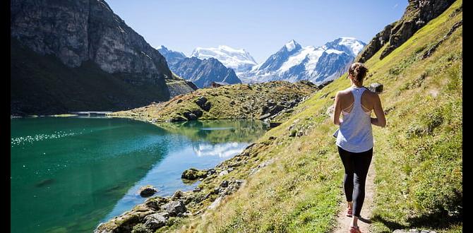
The Black Forest boasts an extensive network of hiking trails, catering to all levels of fitness and experience. These trails are generally well-marked, but understanding the system and having the right map is key to a successful hike. The trails range from gentle strolls through meadows and along streams to challenging climbs up mountain peaks.
Types of Trails
Panoramaweg Trails (Panorama Trails): These trails are designed for scenic views, often following ridges or elevated paths with stunning vistas of the Black Forest landscape. They are usually of moderate difficulty.
Themenwege (Themed Trails): These trails focus on specific aspects of the region, such as local history, folklore, geology, or traditional crafts. They often include informational boards along the way.
Fernwanderwege (Long-Distance Trails): These are multi-day routes that traverse significant portions of the Black Forest. The most famous is the Westweg, a challenging but rewarding trek.
Rundwege (Circular Trails): These are loop trails, perfect for day hikes. They start and end at the same point, making them very convenient.
Trail Markings
German hiking trails, including those in the Black Forest, are rigorously maintained and marked. Look out for:
Yellow Signs: These typically indicate local hiking paths and smaller routes.
Red and White Markings: These signify the challenging Westweg trail, one of Germany’s most renowned long-distance paths.
Diamond Shapes: Often found on trees or posts, these indicate specific trail numbers or routes.
Signposts: Junctions almost always have signposts showing directions, distances to villages or landmarks, and sometimes altitude.
Essential Maps for Black Forest Walkable Routes
Navigating the Black Forest effectively requires the right tools. While trail markings are helpful, a good map serves as your primary guide, providing essential details about distances, elevations, access points, and potential challenges.
1. Official Tourist Maps
These are often the most accessible and visually intuitive maps for beginners.
Where to Find Them:
Tourist information centers in towns like Freiburg, Baden-Baden, Titisee, and Triberg are excellent sources.
Local hotels and guesthouses often provide free regional maps.
Local tourism websites sometimes offer downloadable versions or links to purchase them.
What They Offer:
Clear depiction of major hiking trails, sometimes color-coded by difficulty.
Highlights of popular attractions, viewpoints, and natural landmarks.
Information on public transport links (bus stops, train stations) that serve as trailheads.
Basic elevation profiles for some routes.
Tips for Use:
Always opt for the most recent edition to ensure accuracy.
Familiarize yourself with the map’s legend before you set off.
These are great for understanding the general network but might lack the fine detail of specialized hiking maps.
2. Specialized Hiking Maps (Topographic Maps)
For more detailed planning and navigation, especially for longer or more remote hikes, topographic maps are indispensable.
Publishers to Look For:
Kompass Wanderkarten: This is one of the most popular and reliable publishers of hiking maps in Europe. Their maps are detailed, waterproof, and often include suggestions for routes and points of interest. You can usually find maps of specific Black Forest regions.
Public Press Maps: Another good option, often found in local bookstores.
What They Offer:
Contour Lines: Essential for understanding the terrain, inclines, and descents. This is crucial for assessing hike difficulty and planning your energy expenditure.
Precise Trail Depictions: Show the exact paths, including smaller trails that might not appear on tourist maps.
Detailed Features: Indicate water sources, shelters, caves, forests, meadows, and even individual buildings.
Scale: Typically 1:25,000 or 1:35,000, offering a high level of detail.
Tips for Use:
These maps require a bit more practice to read, but the detail is invaluable.
Consider purchasing maps that cover the specific area you plan to explore. For example, a map of the Southern Black Forest will be different from one covering the Northern Black Forest.
These are ideal for hikers who want to venture off less-traveled paths or have a granular understanding of the route.
3. Digital Navigation and Mobile Apps
In today’s world, technology offers convenient and powerful navigation tools. However, relying solely on a phone can be problematic due to battery life and signal availability.
Recommended Apps:
AllTrails: Offers a vast library of trail maps, user reviews, and GPS tracking. Many users upload routes and provide up-to-date conditions.
Komoot: A popular choice for hikers and cyclists, Komoot allows you to plan routes and download offline maps. It’s excellent for discovering trails and offers turn-by-turn navigation.
Outdooractive: Similar to AllTrails and Komoot, this app provides detailed maps, route planning, and community content. It also offers offline map functionality.
Maps.me: A free offline map app that uses OpenStreetMap data. You can download detailed maps for the entire Black Forest region for offline use.
What They Offer:
GPS Tracking: Shows your real-time location on the map.
Offline Maps: Crucial for areas with no mobile signal. Download maps before you leave home.
Route Planning: Plan your entire hike beforehand, calculating distance and elevation.
User-Generated Content: Reviews, photos, and tips from other hikers can be incredibly helpful.
Tips for Use:
Always download offline maps. This is non-negotiable.
Carry a power bank. Your phone’s battery will drain quickly when the GPS is active.
Learn how to use the app’s features (tracking, route following, marking waypoints) before your trip.
Don’t rely solely on technology. Have a paper map as a backup.
4. Guidebooks and Online Resources
Beyond maps, guidebooks and reputable websites offer curated routes and essential context.
What They Offer:
Detailed descriptions of hikes, including estimated times, difficulty ratings, and highlights.
Background information on the region’s history, culture, and ecology.
Recommendations for transport, accommodation, and food stops.
Reputable Sources:
Official Black Forest Tourism Websites: The Schwarzwald Tourismus GmbH website is an excellent starting point. They often list numerous themed trails and popular routes with downloadable GPS data in some cases. Visit blackforest.info for official information.
Hiking Sub-sections of German Alpine Club (Deutscher Alpenverein – DAV): While the DAV primarily focuses on the Alps, many regional branches and their websites offer extensive hiking information and can be a good resource for trail conditions and safety.
Local Tourism Department Websites: Each municipality within the Black Forest often has its own tourism site with specific local hiking information. For example, the Tourist Office Freiburg website for trails around Freiburg.
Well-regarded travel guidebooks (e.g., Lonely Planet, Rick Steves) often include sections on hiking in the Black Forest.
Planning Your Black Forest Walkable Route
Choosing the right route depends on your fitness, time, and interests. Here’s a step-by-step approach to planning your hike.
Step 1: Assess Your Fitness Level
Be honest about your physical capabilities. Consider:
Distance: How many kilometers are you comfortable walking in a day?
Elevation Gain: Are you prepared for steep ascents and descents? Check the contour lines on your topographic map or the elevation profile on your app.
Terrain: Are you comfortable on rocky paths, or do you prefer well-maintained gravel or paved trails?
Step 2: Define Your Interests and Desired Experience
What do you want to see and do?
Scenery: Are you aiming for panoramic views, dense forests, waterfalls, or charming villages?
Attractions: Do you want to visit specific castles, museums, or natural landmarks?
Pace: Do you prefer a leisurely stroll or a challenging trek?
Company: Are you hiking solo, with a partner, or with family (including children)? If you’re traveling with children, consider their stamina and interest levels. For longer trips or those needing extra support, having discreet and comfortable adult or child diapers can significantly enhance peace of mind and freedom of movement, allowing everyone to focus on the experience. Many brands offer discreet, highly absorbent options suitable for active days out.
Step 3: Choose Your Route(s)
Based on your fitness and interests, select potential routes.
For Beginners/Casual Walkers:
Look for “Rundwege” (circular trails) or “Themenwege” (themed trails) in flatter areas.
Focus on routes that are well-marked and have good public transport access.
Many towns offer “Genießerpfade” (gourmet trails) which are usually well-maintained and lead to nice restaurants or cafes.
For Experienced Hikers:
Consider sections of the “Fernwanderwege” like the Westweg.
Seek out routes with significant elevation changes for a greater challenge.
Use topographic maps to chart your own course.
Step 4: Gather Your Essential Maps and Resources
Once you’ve shortlisted a route, ensure you have the right map.
Paper Map: Purchase a topographic map (e.g., Kompass) for your chosen region.
Digital Map: Download the route onto your preferred navigation app and ensure the offline map for the area is downloaded.
Guidebook/Online Info: Read up on the specific trail, any potential hazards, or recent conditions.
Step 5: Check Weather Forecasts
The weather in the Black Forest can change rapidly, especially at higher elevations.
Always check the forecast for the specific region you’ll be hiking in, not just a general forecast for Germany.
Be prepared for rain, wind, and cooler temperatures, even in summer. Layering clothing is key.
Step 6: Pack Accordingly
Your backpack should contain essentials for safety and comfort.
Navigation: Paper map, compass, fully charged phone with GPS/offline maps, power bank.
Clothing: Moisture-wicking base layers, insulating mid-layers, waterproof and windproof outer shell, extra socks, hat, gloves.
Footwear: Sturdy, broken-in hiking boots or shoes with good grip.
Food & Water: Enough water for the duration of your hike, plus high-energy snacks.
Safety: First-aid kit, whistle, multi-tool or knife, sun protection (sunscreen, sunglasses, hat), insect repellent.
Comfort: Trekking poles can be very helpful, especially on descents. If you anticipate needing extra security or to manage continence during strenuous hikes, discreet adult diapers or pull-up styles can provide confidence. Similarly, having well-fitting child diapers for younger hikers ensures they remain comfortable and focused on the fun, preventing disruptions.
Featured Black Forest Walkable Routes & Map Insights
Here’s a look at some popular regions and how their maps cater to walkers.
1. The Titisee-Neustadt Area
Titisee is a famous lake and tourist hub in the Southern Black Forest.
Map Focus: Tourist maps here often highlight the lake circuit (approx. 4-5 km, easy) and routes leading to nearby viewpoints like the Hochfirst Viewing Tower. Specialized maps will show trails around the lake and up into the surrounding hills.
Recommended Map Type: A good regional tourist map is sufficient for the lake circuit and many designated viewpoints. For longer forest hikes, a detailed Kompass map of Hochschwarzwald (Southern Black Forest) is recommended.
External Resource: The official tourism site for Titisee-Neustadt will have maps and route suggestions: Titisee-Neustadt Tourism.
2. The Feldberg Region
Feldberg is the highest peak in the Black Forest, offering dramatic alpine scenery.
Map Focus: Maps of Feldberg showcase numerous circular routes around the summit, trails to glacial cirques (like the Feldsee), and connections to the Westweg. Elevation is a key factor, so contour lines are essential.
Recommended Map Type: A highly detailed topographic map (1:25,000) for the Hochschwarzwald region is crucial for navigating the varied terrain and steep ascents/descents around Feldberg. Apps like Komoot with detailed elevation data are also excellent here.
Key Trails: Feldberg-Steig (a premium hiking trail), loops to the Feldsee.
3. Triberg Waterfalls and Surrounding Forests
Triberg is known for its dramatic waterfalls and picturesque village.
Map Focus: Maps here emphasize the trails leading through the gorge to the waterfalls (entry fee often applies) and the network of forest paths in the surrounding areas. Smaller, themed trails about local history or nature are also common.
Recommended Map Type: A local area map from the tourist information center is often sufficient for the immediate waterfall area and short forest circuits. For exploring further into the Black Forest National Park that is not far from Triberg, a more detailed map focusing on the National Park region would be beneficial.
External Link: Information on Triberg’s attractions and some trail details can be found via the official Triberg website: Triberg Tourism.
4. The Mummelsee and Hornisgrinde Area
Located in the Northern Black Forest, this area offers a mystical lake and the region’s highest peak.
Map Focus: Maps highlight the circular path around Mummelsee, the ascent to Hornisgrinde, and routes connecting to the Westweg. The terrain can be boggy in parts, so map detail is important.
Recommended Map Type: A Kompass map of the Northern Black Forest or a good topographic map of the Schwarzwaldhochstraße area is highly recommended. Apps with detailed terrain views are also useful here.
* Key Trails: The path around Mummelsee, ascent to Hornisgrinde.
Table: Map Features Comparison
| Map Type | Detail Level | Ease of Use for Beginners | Best For | Key Features |
| :————————— | :———– | :———————— | :———————————————– | :—————————————————– |
| Official Tourist Maps | Low-Medium | High | Casual day hikes, getting an overview, families | Attractions, major trails, public transport |
| Specialized Hiking Maps | High | Medium | Serious hikers, off-trail exploration, planning | Contour lines, precise paths, detailed terrain |
| Digital Navigation (Apps) | Variable | High (once learned) | Real-time tracking, planning, backups | GPS, offline maps, elevation profiles, user reviews |
| Guidebooks/Online Resources | Medium | High | Route ideas, background info, planning context | Hiker reviews, history, difficulty ratings, transport |
Using Your Map Effectively on the Trail
Having the best maps is only half the battle; knowing how to use them is crucial for safety and enjoyment.
Before You Go
1. Study Your Map: Familiarize yourself with the general area, your starting point, your planned destination, and any significant landmarks or terrain features along the way.
2. Identify Key Waypoints: Note junctions, summits, water sources, and potential rest stops.
3. Estimate Time: Use the map’s scale and any provided difficulty ratings or typical walking speeds to estimate how long the hike will take. Add buffer time for breaks and unexpected delays.
4. Plan Your Return: If it’s not a circular route, know how you’ll get back to your starting point or to public transport.
On the Trail
1. Orient Yourself: Use a compass and visible landmarks to ensure your map is oriented correctly with the terrain around you. Point the “North” on your map towards true North.
2. Track Your Progress: Periodically check your map to confirm your location. Look for trail markers and compare them to your map.
3. Anticipate Turns: Ahead of junctions, consult your map to ensure you’re taking the correct path.
4. Understand Altitudes: If you’re using a